When it comes to staying on track in the great outdoors, two sets of tools are indispensible. GPS receivers are the newest technology, and in trained hands can be fantastic because they not only tell where you are and show the way, but they can “remember” where you’ve been or be pre-loaded with loads of helpful information. But they’re not infallible...not if the batteries die, the unit is broken or satellite signals are blocked. Because the alternate “old-school” tool set is more durable and more foolproof, wilderness survival experts still consider it invaluable, even in the GPS age. That set consists of a topo map and compass.
Reading Topo Maps
Topographic maps may look like a jumble of colored lines and symbols, but for those in the know, they accurately portray an area’s geographic features. Because the landscape is three-dimensional, and the map has only two dimensions, lines are used to convey variations in elevation, as well as features like rivers and roads.
Printed in red (or sometimes brown) are what are called contour lines, which indicate a specific elevation above sea level. Every fifth line will be bolder, and usually is marked with a number that states its elevation.
The contour lines often appear as circles within circles, irregularly shaped, each circle smaller as they progress to the middle. That smallest circle? It’s the top of a mountain ridge or hill. On the most commonly used topos, each circle, or contour line, represents 50 feet of elevation.
And so the closer the lines, the steeper the slope. A sheer cliff will have contour lines right on top of one another, or extremely close. But a 40-foot cliff probably won’t show on a map with 50-foot contour intervals.
Topo maps also include colored symbols: rivers are solid blue; forests are green; buildings are a black rectangle; roads are solid or parallel lines; and off-road or hiking trails are dotted or dashed lines. For a complete lists of symbols visit www.usgs.gov or consult any advanced map-and-compass book.
But some of the best secrets are found in unmarked clues. A small drainage where deer or elk might escape detection or where you might find emergency shelter will make a small indent or “V,” on a contour line—where the water has lowered the landscape’s elevation. You can use such clues to find your way. Why climb the steepest face of a ridgeline when you know how to find a gentler slope?
The maps also detail much more, including names of nearby towns, mountains, forests and even campgrounds. The bottom of the map also provides magnetic declination, as well as a distance scale and what year the map was created. Adjacent maps are also indicated on corresponding sides.
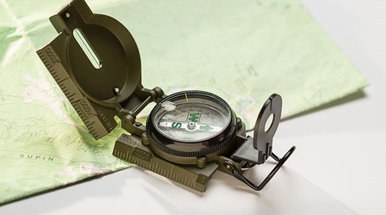
Compass Reading
A compass points to magnetic north. To take a reading, get a few feet from anything metal, like a vehicle, rifle or table. Compasses, including digital models, should also be used well away from electronic items like cell phones and watches.
Put your map down. Place the compass on top, making sure it’s level and when its needle stops moving the letter N (or red indicator) will point north. Turn your map so that the top of the map—its north end—is being pointed at by the compass. Now your map is properly oriented.
If you know where you are, like at a campground or trailhead, find that spot on the map, and move the compass directly over it. Find something of interest directly to the east of your position on the map, a mountain/hill, stream or road is a great way to start. Make sure it’s close enough that there’s nothing to block your view.
Now stand up with the compass, holding it level. Once it stops moving, turn so you’re looking directly north. Now look east—to your right—and see if you can find that designated spot. Unless something’s in your way, or you picked a spot too far away, it should be visible. Try the same to the west and south.
Do this several times until you’re comfortable getting your bearings. Find it on the map, then find it with your compass. Once you’ve mastered relatively simple map/compass reading, you should be ready to get there and back during typically short excursions into the backcountry.
Advanced Work
Finding your way along an extended or truly remote unknown route requires more advanced understanding, beginning with an accurate determination of your position. Although today’s GPS units make this quite easy, using a compass requires quite a bit more skill and practice. One complication is magnetic declination—the difference between magnetic and true north, which actually varies by region. This must factor into your calculations, and the use of a lensatic compass, which allows you to aim at distant features for accurate compass readings, is almost mandatory.